Looking at numbers on a spreadsheet is one thing. Showing what the numbers mean is another, especially when it comes to visualizing water flows.
The flow of water can be tracked and analyzed by scientists. But bringing data to life is the goal of projects by boards including the IJC’s Rainy and Namakan Lakes Rule Curves Study Board.
“There are some complicated hydraulic conditions upstream of the international dam that can significantly limit how the lake levels on Rainy Lake can be managed. This can be challenging to explain to a layperson, and a visualization tool can make it easier to understand the issues,” said Wayne Jenkinson, senior engineering adviser in the IJC’s Canadian Section office.
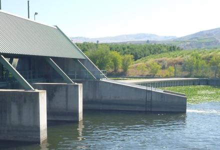
That’s the dam between Fort Frances, Ontario, and International Falls, Minnesota. Two videos are being used by the board to explain how the Rainy Lake outflow is managed, and factors and natural forces that affect levels and flow.
The first illustrates features of Rainy River and Rainy Lake that impact the flow of water, and how controls on river and lake levels are affected and influenced by channel features in the upper Rainy River.
Understanding Rainy River and Rainy Lake Outflows from International Joint Commission on Vimeo.
The second video explains limits on the ability of international dam to adjust the outflow from Rainy Lake.
Understanding Rainy River and Rainy Lake Outflow #2 from International Joint Commission on Vimeo.
A third video under production is designed to walk viewers through an interactive tool that lets people take virtual control of the dam and experience the effects of opening and closing the structure’s 15 gates. The tool can be found here.
Charlene Mason, a US member of the Rainy-Lake of the Woods Watershed Board from Minnesota, said she thinks the videos have been successful. They help convey constraints on water management, including at Ranier Rapids where the river starts and just above the dam at the former site of Koochiching Falls.
“There’s a point where you just can’t do anything,” Mason said. “You’re going to have flooding every once in a while and the dam operators are doing all they can given the structure of the river.”
Mason said public meeting attendees have noted that the videos helped explain the ins and outs of water management. “I’ve heard people say, ‘Oh yeh, that’s how it works! I can understand it a little bit better now.’”
Jenkinson added that the simulation tool also has been brought up at public meetings, where people said they’d experimented with it and realized there’s only so much dam operators can do to control water levels.
Ivana Vouk, research council officer for the National Research Council of Canada, said her organization is helping with other visualization projects for IJC boards. One is a dashboard prototype showing historic and near-real-time precipitation and water levels in the Rainy-Lake of the Woods basin.
“The overall idea is that anyone in the community, in that watershed, can go online and see a snapshot of what’s happening currently within their subbasin,” Vouk said. That includes viewing integrated precipitation and water levels information from both Canadian and US sources.
See also: Public Hearings and Public Comment Period on the IJC's Draft Changes on the Rainy and Namakan Lakes Rule Curves.