An Overview of Great Lakes Diversions
The International Joint Commission does not have authority over these diversions. This fact sheet is for informational purposes only.
Background
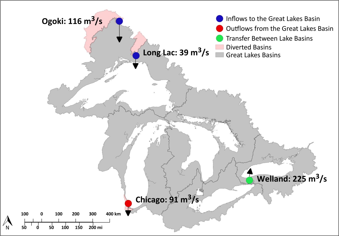
The major diversions in the Great Lakes basin that affect water levels are diversions into Lake Superior at Long Lac and Ogoki, the Chicago diversion out of Lake Michigan and a diversion between lakes Erie and Ontario through the Welland Canal.
These three diversions have a relatively minor effect on water levels compared to natural factors, including weather and water supply conditions, as well as the flows between the lakes through the connecting channels, including the regulated outflows of lakes Superior and Lake Ontario.
The Long Lac and Ogoki diversions, located in northern Ontario, divert water from a portion of the Hudson Bay watershed into the Lake Superior basin. The Long Lac diversion began in 1939 and the Ogoki diversion began in 1943. Often times these two diversions are considered as one because they are both diverting flows from the same watershed. They are operated by Ontario Power Generation.
The Chicago diversion, located in Chicago, Illinois, diverts water from the Lake Michigan watershed into the Upper Mississippi River basin. The Chicago diversion began in the early 1800s and increased in 1900 after the Chicago Sanitary and Ship Canal was completed. The first US Supreme Court decree in limiting the Chicago diversion was effective in 1925, and the latest decree of 1967, modified in 1980, limits the annual diversion to 91 cubic meters per second (3,200 cubic feet per second). It is operated by the US Army Corps of Engineers.
The Welland Canal is a navigation route which bypasses Niagara Falls and diverts water from Lake Erie to Lake Ontario. The first canal was built in 1829 and was steadily improved over the years, including the addition of diversions for hydropower. The present configuration was set as a result of the 1950 Niagara Treaty. It is operated by the St. Lawrence Seaway Management Corp.

Combined Effects
The combined effects of the Long Lac, Ogoki and Chicago diversions and the Welland Canal have been to permanently raise Lake Superior by an average of 2.1 centimeters (0.8 inches), lower Lakes Michigan-Huron by 0.6 cm (0.2 in), lower Lake Erie by 10 cm (4 in) and raise Lake Ontario by 2.4 cm (1 in), according to the IJC’s 1985 Great Lakes Diversions and Consumptive Uses report.
Figures 2 and 3 show the historical annual average flow values for the different components contributing to water level changes on Lake Superior (top) and Lake Michigan-Huron (bottom). Note that lake levels fluctuate because inflows and outflows are not always at historical averages.


Potential local effects of changing Long Lac and Ogoki outflows
Since the creation of the Long Lac and Ogoki diversions, local ecosystems, communities and industries have adapted to the modified flow regimes.
Changes to the diversions could dramatically alter the ecosystem and fish habitat both in the Albany River system to the north, and in the Long Lac and Lake Nipigon basins to the south. This would impact commercial and recreational fishing activities of various communities in these areas.
The potential loss of hydropower production from suspending or reducing the diversions also would be significant for Ontario Power Generation (OPG) and the government of Ontario, Canada.
Increased flows north into the Albany River system also would interfere with hunting and logging activities, and have the potential to increase spring flooding of First Nations communities at the mouth of the river near James Bay.
Potential local effects of changing the Chicago diversion
Changes to the amount of water diverted out of the basin at Chicago could have significant impacts on the Chicago area.
Identifiable impacts would be a loss of flood storage on the Chicago Area Waterway System, creating a risk of flooding downtown Chicago, a halt to navigation on the waterways, erosion of the banks, ecological degradation of the system, and significant life and safety issues downtown (or any locale adjacent to the Chicago River).
There also would be implications further downstream. Increases or decreases in flow through the Chicago River could exacerbate flooding or drought being experienced along the Illinois River.
Last updated April 2020. Prepared by International Joint Commission, IJC.org