
Record-setting water levels in Lake Champlain in spring of 2011, followed by devastating rain from tropical storms Irene and Lee later that year made it clear that regional flood prevention measures needed further development.
From warning systems and emergency response to post-storm water quality assessments, resource managers across Vermont, New York and Québec recognized the growing importance of working together to prepare for the next big event.
In 2012, the IJC assembled a Canadian-U.S. team that investigated regional flood mitigation needs. Their findings highlighted the need for basin-wide datasets to be used for flood prediction, infrastructure planning and habitat mapping, and improved flood resilience.
Integrated datasets are an essential stepping stone toward resilience, and efforts are now underway to secure high-resolution data basin-wide.
Sub-meter resolution airborne laser altimetry, known as LiDAR, provides exceptional information about the elevation and shape (micro-topography) of the earth’s surface and has become a foundational dataset for shoreline conservation. It is considered a key component of flood risk assessment and related planning.
But LiDAR data acquisition is costly because it must be specially flown by low-altitude aircraft and generates such detailed information that the datasets are enormous. For that reason, agencies at local, state and federal levels have partnered together with a collaborative approach to solve a common need for this terrain data.
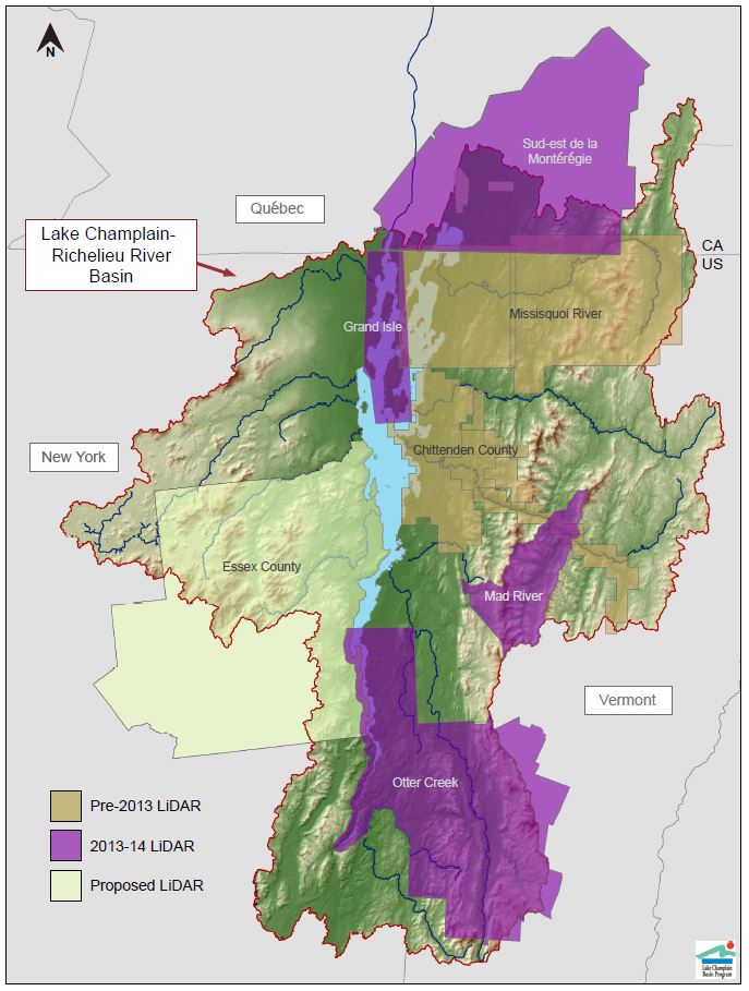
A map of the current and proposed extents of the LiDAR project. Credit: LCBP.
Thanks to these cooperative efforts throughout the watershed, the past few years have seen a rapid expansion of LiDAR data acquisition in the Champlain Basin, from 1,500 to 2,200 square miles of coverage.
The state of Vermont began acquiring LiDAR for planning purposes in 2003, securing data for its most densely populated area, Chittenden County. In 2010, the IJC supported the acquisition of LiDAR for targeted water quality management efforts in the Missisquoi Bay watershed, which spans the Vermont-Québec border, in support of a nutrient modeling effort. The resulting information shows where on the landscape pollution most likely originates and is useful for targeting scarce management resources.
By the end of 2013, nearly the entire Vermont and Québec portions of the Lake Champlain Basin had LiDAR data available. The partners now are seeking funding to add much of the New York sector of the watershed. If the New York portion is achieved, the Lake Champlain-Richelieu River watershed will have more than 5,500 square miles of LiDAR coverage --- a rare feat in a large, diverse watershed.
This compilation of data will allow a vastly improved understanding of the character of riverbanks and shorelands vulnerable to flood damage. The whole effort also showcases the effectiveness of diverse agencies reaching across borders and working together to achieve goals that are otherwise not possible. The new micro-topographic datasets will enable more accurate hydrologic modeling and flood predictions to support the Richelieu River-Lake Champlain Basin flood mitigation study recently recommended by the IJC.
 A farm along the Lamoille River in Vermont that flooded after Tropical Storm Irene in August 2011. Credit: Bill Howland, LCBP.

William G. Howland, Ph.D Lake Champlain Basin Program