The Prairie Climate Atlas is a new interactive website designed to communicate the implications of climate change to those who live and work in the Canadian Prairie Provinces of Alberta, Saskatchewan and Manitoba.
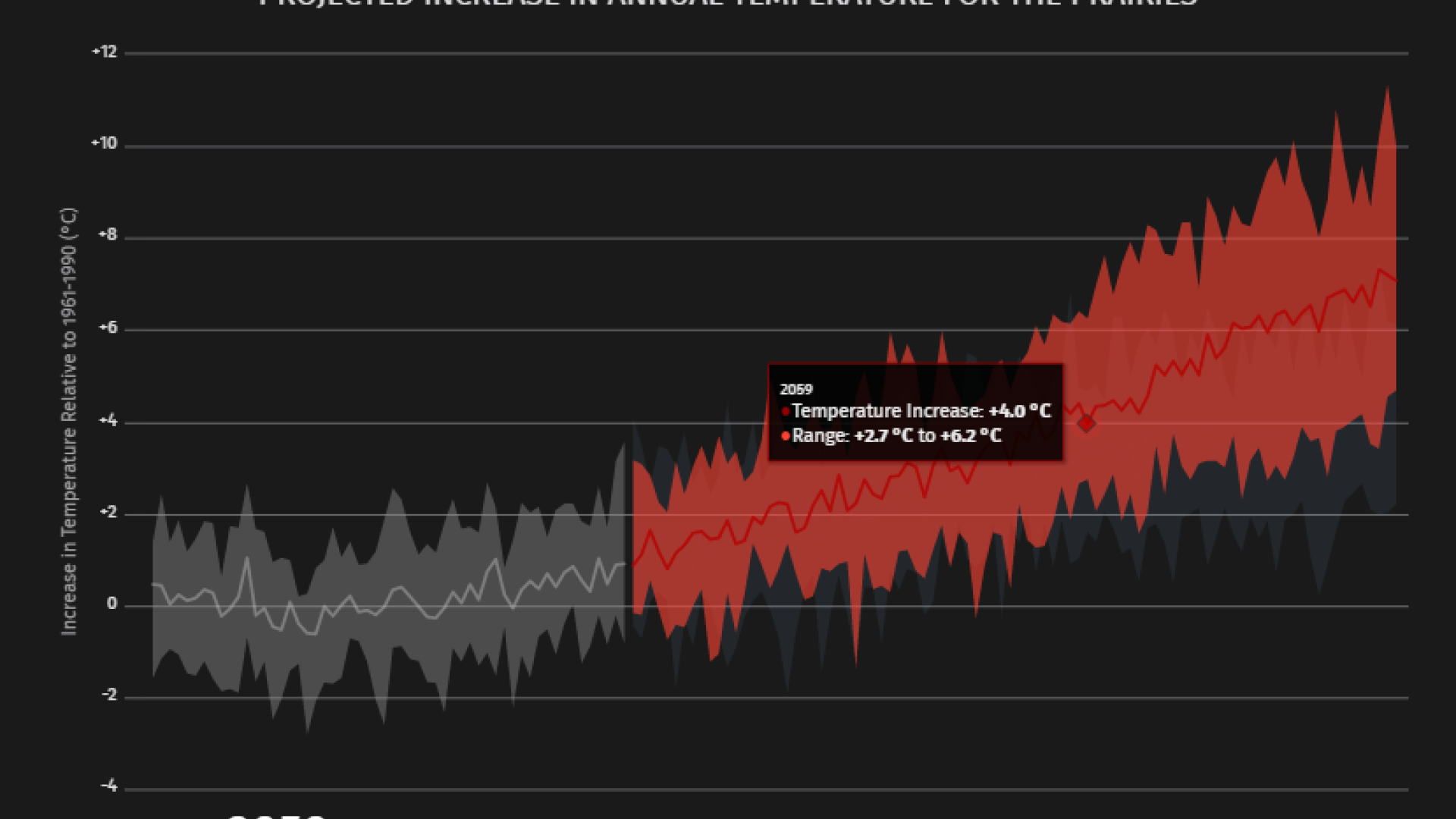
The Atlas is the flagship product of the new Prairie Climate Centre at the University of Winnipeg. Climate models have long indicated that northern, continental climates – including the climate of the Canadian Prairies – are expected to warm much faster than the global average. Indeed, the severity of the warming illustrated by the Atlas points to profound challenges ahead for the region, especially if little to nothing is done by the international community to limit the release of greenhouse gases.
About the Atlas
When users first visit the Atlas, they are shown the differences between high and low carbon emission futures. In the high carbon future, sometimes referred to as the “business as usual” scenario, humanity continues to emit more and more greenhouse gases into the atmosphere over the next century.
The low carbon future is based on a mixture of renewable energy programs and ecologically-minded policies that gradually release us from our fossil fuel addiction (an even lower emissions scenario exists — one that challenges the international community to reach carbon neutrality much sooner; however, most research projects — including ours — do not showcase data from this very ambitious scenario).
Each map and graph in the Atlas includes an option to toggle between the high and low carbon futures, so that users can see the benefits of working hard and soon to reduce emissions.

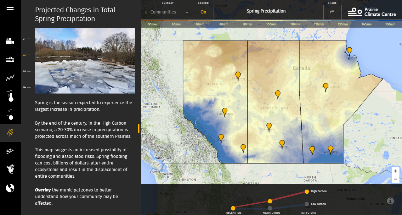
The Atlas features many interactive maps from the Pacific Climate Impacts Consortium that beautifully display the outputs of high-resolution climate models. Traditional climate model data come in very coarse-resolution formats, making it difficult to show how climate change may impact specific towns or municipal zones. In the Atlas, users can click on maps to get location-specific climate change statistics, including changes in the annual number of hot and cold days, seasonal precipitation totals and the length of the growing season.
Climate change and water issues across the Prairies
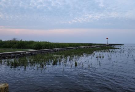
The Prairies is a region plagued by water issues; seasonal flooding, periodic droughts and severe thunderstorms capable of causing flash floods are an all too frequent reminder of how vulnerable Prairie dwellers are to water quality and quantity issues. According to the Atlas, winters and springs are projected to get much warmer and wetter, greatly increasing the risk of seasonal and flash flooding.
While summer heat is expected to skyrocket in the future — with many locations expected to witness a tripling or even quadrupling in the average annual number of days that go above 30 degrees C (86 degrees F) – summer precipitation is projected to decrease across the region. The combination of extreme heat and low rainfall is the perfect recipe for drought, the most costly type of natural disaster the Prairies can experience.
Even though summers are projected to become drier in the future, climate models suggest that the frequency of extreme rainfall events may actually increase. The types of storms capable of dropping an entire season’s worth of rainfall in a few short hours are projected to become more common as the climate continues to change.
What can be done?
Much can still be done to prevent us from experiencing the worst climate change impacts illustrated in the Prairie Climate Atlas. Building our societies around more sustainable, environmentally friendly energy and infrastructure projects will help ‘bend the curve’ away from the dramatic changes associated with the high carbon scenario. However, climate change is occurring now, and greenhouse gas emissions released to date make at least some future climate change impacts unavoidable.
Adaptation planning must now begin in earnest across the Prairies – and the globe – to prepare for the coming changes. Water management will become an increasingly complex job, as water from wet periods will likely have to be saved for times of water shortage. The Prairie region includes watersheds that straddle the international border, meaning that the role of agencies like the IJC will likely become ever more important in the years to come.
Other Resources
Other websites in Canada and the United States that present climate change model data include:
- Alberta Climate Records, with data and temperature trend analysis from the Kienzle lab at the University of Lethbridge
- Goddard Institute for Space Studies, also from NASA
Ryan Smith is a climate change researcher with the Prairie Climate Centre and was the lead designer of the Prairie Climate Atlas. Smith teaches a course on climate change and variability at the University of Winnipeg, where he challenges his students to think outside the box when it comes to communicating the impacts of climate change to the public. He currently sits on the board of the Canadian Water Resource Association’s Manitoba Branch, and gives many talks to policymakers, scientists and members of the public about the science and dangers of climate change.

Climate change researcher with the Prairie Climate Centre and lead designer of the Prairie Climate Atlas.